


HOME > Search for Paper Products
Search for Paper Products
Nautical Charts
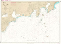
For navigatonal safety and efficiency, details of coastal topography, soundings and shoals as well as positions of aids to navigation and currents and tidal currents, etc. are charted.
Detail
- Select Region
Basic Maps of Sea (Coastal)
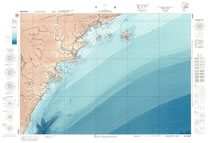
Consist of two types, Submarine Topographic Charts and Submarine Structural Charts. They cover the coastal waters of Japan with scale of 1/50,000 and 1/10,000 series.
Detail
- Select Region
Yachting Charts (Y Chart)
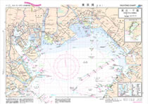
B3 size multiple-colored charts incorporating the updated navigational information from offshore to coastal areas such as landmarks, courses, obstructions, etc. for mariners maneuvering pleasure boats.
Detail
S Guide Images(Download)
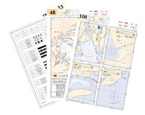
Digital handy booklets considering of reference charts plainly indicating such maritime information that are not usually shown in details on nautical charts, e.g. landmarks, shipping courses, obstructions, marin information, etc. in and around small ports and yachting harbors.
Detail
- Select Region
-
- South Coast of Honshu 1 (Tokyo W
- South Coast of Honshu 2 (Daio Sa
- Eastern Part of Seto Naikai (Osa
- Western Part of Seto Naikai (Aki
- NW Coast of Honshu (Hibiki Nada
- North and East Coasts of Honshu
- Nanpo Shoto (Izu Shoto,Ogasawara
- NW Coast of Kyushu(Genkai Nada-S
- SW and E Coasts of Kyushu and Na
- S & E Coasts and Eastward of Hok
- N & W Coasts of Hokkaido(Shireto
- Nansei Shoto (Okinawa Gunto, Sak